After sharing my Timp experience and love of hiking, another friend and I made plans to summit Mt. Olympus in Salt Lake. Olympus is unique to most hikes I’ve done in that it’s right next to the city…the trailhead is a couple minutes off the freeway, at 5789 Wasatch Boulevard. It’s also exceptionally short horizontally…but exceptionally steep vertically.
We met at the trailhead just after 8AM and started climbing. The first stretch gets you warm right away, with fairly steep steps for a few dozen meters. As you get to the top of Pete’s Rock(a tall, prominent rock that you could rock climb from the trailhead), you’ll likely see a little trash and a small fire site…and then realize you took one of many, many alternate or false trails along this summit hike.

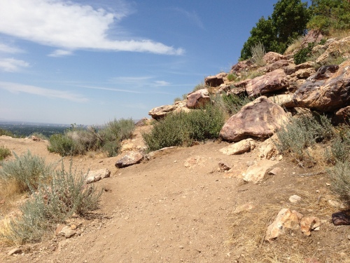
“Clearly I need to continue the trail to the left.” You’d be wrong. The trail continues on the right, up the rocks. One of many poorly marked trail forks on the road to Olympus.
We continued past the small hang out site on the trail, but thankfully, we quickly thought there was something wrong about continuing downhill. I climbed up Pete’s Rock a ways and saw the summit trail continue uphill once you climb up the rocks there. This is something you have to pay attention to on this hike: there are several spots where an alternate trail(apparently leading to the Bonneville Shoreline, most of which are marked with a small sign) or a false trail branches from the main one. The latter of which are typically not marked at all(except maybe a couple rocks on the trail that don’t help deter much, as you may, or may not, have spotted in the above photo), usually aren’t very good paths, and take you a bit further, but ultimately lead back to the main trail. If you think the trail suddenly became pretty poor, there’s a chance you’ve taken one of these.
After the initial steep steps, the trail becomes pretty mild for a while on some switchbacks. Starting this early makes almost the entire ascent shaded, as the sun hasn’t come up over the west side of the mountain yet(the picture above was taken as we descended). You’ll go probably around 2 miles in these sort of conditions. After about that length, one member of our group decided his back had had enough, and chose a shady spot on the side of the trail to wait. He choose a great spot.
Shortly after we continued, Olympus became a true beast. Let there be no mistake: Olympus is a rigorous peak to summit. For probably another mile we went up a steep incline(probably averaging around 30%) in thick vegetation until we reached a sort of saddle. The trail levels out for a short while, you’ll see a few small camp/fire sites and a fantastic view directly ahead.
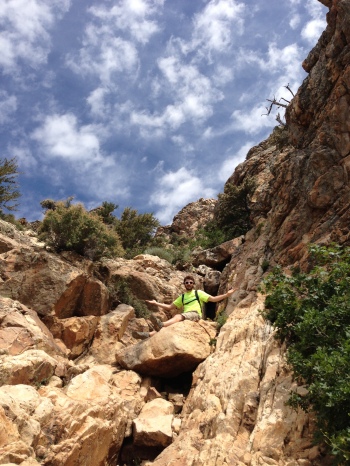
The trail continues left, and doesn’t get easier….from here on out, you’re bouldering/climbing to the summit. There were a few cairns to mark the way, but none extremely helpful(we added a couple). After you start heading north at the saddle, you’ll continue north and somewhat east until the summit. There’s never a point where you’re truly rock climbing on a level 5 wall, but you will be using your hands and pulling yourself up much of the way, like a giant staircase to the top.
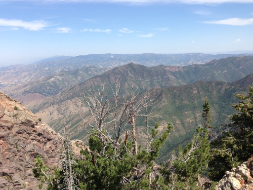
At the very top you’re almost exclusively hiking on large boulders, and there will be a few registry notebooks in a mailbox for you to sign. We were able to summit just around noon, to great weather. No wind, no clouds, and not too hot. We enjoyed some lunch and the views before descending. The views cover Salt Lake Valley, some smaller mountain ranges to the north, and some other taller summits to the south.
Any hike tends to be fairly abusive on the legs on the way down, but that was especially true for Olympus. Creeping down the boulders at the top wasn’t too bad, but that mile or so of steep, rocky trails downward required careful attention to footwork to make sure there were no ankle or knee injuries. We met up with our friend about halfway down and took the rest of the fairly mild trek down. We were in bright sun for most of the descent, and it was starting to get hot at this point. We all ran out of water, but only when we were nearly done(I think most of us brought a typical 2 liter camelbak). Few things match the feeling of reaching the top….and bottom….of a good summit hike.
Mt. Olympus is roughly 3.75 miles both ways, for about a 7.5 mile/12 kilometer round trip. This is, for it’s short distance, a very difficult hike, averaging a 21% grade. In comparison, Timpanogos averages 11%, and Nebo 15%; the three peak hikes cover similar heights over widely different stretches. I find the time to ascent vs. the time to descent for most hikes is much closer than I would think, but Olympus took almost twice as long to climb than to return(just under 4 hours compared to just over 2). We began at about 8:10AM, summited at 12:05, began climbing down around 12:30, and reached the parking lot near 2:45, for a total of just less than 7 hours. Cell service was strong the whole trip.
The views weren’t quite what King’s Peak or Mt. Nebo offer, but Olympus has advantages in the proximity of it’s trailhead and as a great workout in less of a time commitment. The path isn’t as clear as I’d have liked in some places, but still isn’t difficult to follow. With the steepness and climbing portions near the end, inexperienced hikers, kids, and maybe even some dogs may have a hard time reaching the summit. The parking closes between 10PM and 6AM, and the hike is pretty short, but there were spots where I imagine you could camp at the saddle if you wished.


Pingback: Trip Report: Provo Peak 2013 | Adventures...or whatever.