Category Archives: Trip Reports

Trip Report: Cascade 2014

Realizing we hadn’t planned something for our usual Tuesday hike and that doing Cascade would check off the last of Utah Valley’s 7 Peaks for me, my roommates and I more or less spontaneously decided to bag it.

Little did we know what we were in for.

I’m not sure if it was on the way up as we were bushwhacking our way over the umpteenth craggy, dense ridge hill (each one more mocking than the last, seemingly never turning into the true summit) or on the way down when all of us were out of water and ignoring how disgusting the snow we were melting to drink was, but at some point I decided those who say Lone Peak is the most challenging non-technical hike in Utah are full of it. Or, perhaps, like the vast majority of them, they haven’t done Cascade…or, if they have, they’ve decided it was worthy of being classified as technical.

At any rate, make no mistake: this is an extremely trying hike. You may notice, like I did, that experienced hikers posting trail reports mysteriously report a round trip time of 11 or 12 hours, despite similar length and elevation-gain hikes taking them 5 or 6. I say mysterious because, in my opinion, almost none of the trail reports out there properly warn you for what you’re about to face. For this reason, I think many take it for granted…myself included.

Don’t get me wrong, we did our best to prepare for what we knew would be a challenge, even with several peaks already under our belt this summer. Mentally we were ready for a trial (set what we thought was a realistic goal of 10 hours); our bags were full of food and at least 3L of water; we started as early as we could (7:30AM on the trail). However, it wasn’t meet for what Cascade throws at you.

There are a few different routes to get to the top; the most reliable one seemed to me to be the Dry Fork route, which is 9.5 miles up Squaw Peak road once you turn onto it from Provo Canyon (The second most promising, in my opinion, was the trail starting up past Vivian Park in the same canyon). Here’s a Google Maps pin: https://www.google.com/maps/dir//40.2689904,-111.5791157/@40.2703569,-111.6106604,6299m/data=!3m1!1e3!4m3!4m2!1m0!1m0

The first half of the trail is a decently steady slope, leading towards the ridge between Cascade and Freedom. You’ll start to get into some meadows, where many people see the gullys that head straight toward the ridge and diverge (we decided in advance that we wouldn’t diverge from the trail, having read so many stories of failed shortcut attempts). Past the meadows you’ll head towards the right (south), veering towards Freedom Peak, and Provo Peak just southwest of that. As you get directly below Freedom, you’ll switchback left, and start going up towards the ridge. As you get to the top, you’ll see a fork–stay left on trail 059 (the Dry Fork trail begins off Squaw Peak road as trail 060, for the record).

You have maybe 1/3 of a mile of trail left, mostly downhill. You’ll reach a small area where people appear to have camped, and see a strange, large (maybe 6′ by 10′) plastic basin-like thing (we wondered if maybe it was for catching rain water so people could filter it for the hike?). This is where the real fun begins.

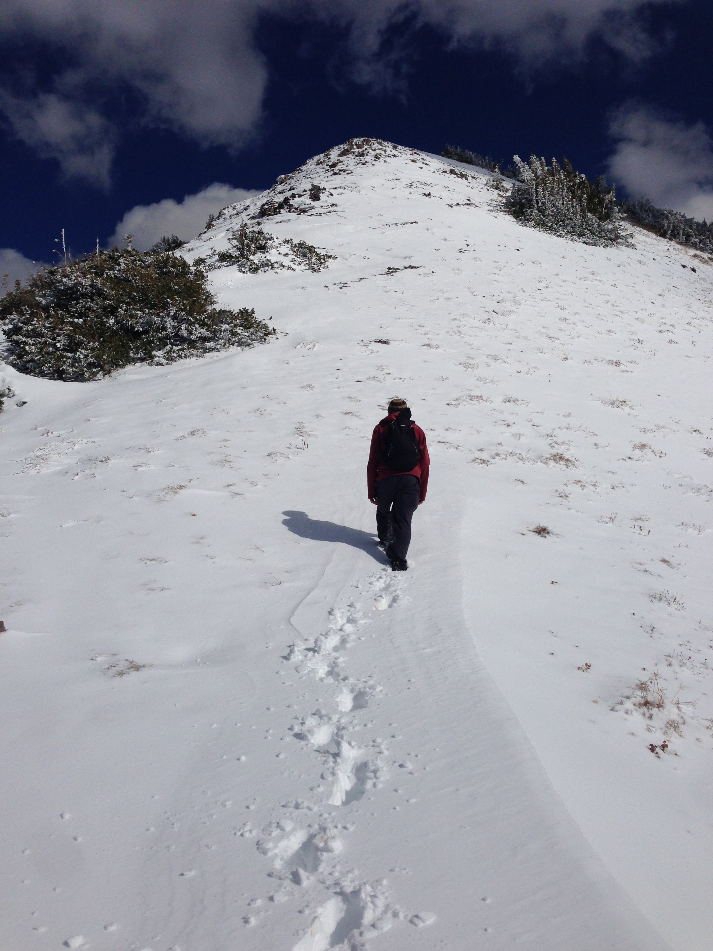
Don’t underestimate what you’re about to attempt. Cascade doesn’t quit, and doesn’t give any mercy. I also suggest not trying to be clever about this. You’ll go up and down (my guess is the ~3,700ft you gain in this hike is probably closer to around 5,000 with the ups and downs of this ridge) over ridge peaks for around 3 miles, with tons of trees and loose ground that love to make things difficult for you. There is no trail. Yes, there are rough outlines of trails around, but many of them will lead you where you don’t want to go, so unless they are remarkably obvious and clearly lead where you want to go, be careful.

I think the best rule of thumb is to stick to the ridgeline as closely as possible. There are trails that look like they avoid unnecessary elevation gain on a ridge hill; they often just skirt halfway around it then force you to go straight up to the top over loose dirt and shale. I won’t pretend to know the best way to take this portion of the hike, but very, very rarely did I regret not just sticking as close to the highest point along the ridge as I could. It’s often where the path is cleanest, and overall requires the least amount of effort. You will run into areas where the ridge is totally blocked by thick brush and trees, but typically you just skirt right below that brush and come right back up.

Particularly on the way back we thought we could be clever, since now we’re heading downhill anyway, right? Wrong. Stay close to the ridge. It’s your best bet. Should you choose to take a gully shortcut, please carefully know your path via maps beforehand and be careful.

The first summit that completely convinces you you’ve reached the top is often the false south summit. There is a cairn and a registry in a small jar hidden nearby. However, the highest summit of cascade is still two ridge hills away (note again: two ridge hills. It was very disappointing to reach the first and realize it, once again, wasn’t the summit). The path between the south and north summits is likely the simplest path of the ridge. There is a cairn at the north summit as well.

Enjoy the summit. The views really are amazing, it’s a largely unobstructed 360 degree view. You can see all of Utah’s biggest peaks besides Lone.

Follow the same general guidelines on the way back. As I mentioned, we ran out of water, and this was a very mentally taxing return trip. One of our party started to feel some real pain as his shoes were wearing thin and his legs were getting charley horses. Once we were out off the ridge the sun was beating down on us, but we trudged through and actually did make our goal of 10 hours, arriving at the car just past 5:30PM.

Just doing the math with distance and elevation gain (about 6.5 miles one-way and gaining around 3,700ft), you have an average slope of 10.7%…however, this is entirely deceiving. If my guess of that reaching 5,000ft with the ridge hills is accurate, we actually have an average around 15.4%, and of course, it’s actually much steeper during the uphills, since some portions of the hike are downhill. In addition, there is more brush and pathfinding necessary to summit Cascade than any other hike I’ve done. I think I would qualify this as the most challenging peak I’ve done, even more than King’s or Whitney, especially from a mental perspective.

Please don’t underestimate this hike; but if you are feeling up to a real challenge, go get that view from the top. I will update this post with pictures and additional detail soon.

Leave a comment

Filed under Trip Reports

Trip Report: Lone Peak 2014

Lone Peak. Often considered the most difficult non-technical summit in Utah, and the northernmost of the 7 peaks of Utah County. I’ve had my eye on it since I first started hiking, as had my sister Mica, who originally hooked me to hiking when we did King’s Peak in 2012.

We decided to do the Schoolhouse Springs trail, which approaches Lone from the south end, instead of the more common Jacob’s Ladder trail from the north. We relied primarily on this post as our guide. I’ll try to enhance the information given there.

Here’s Google Maps pin of the trailhead. You continue past the pinned point up the dirt road until you get to the water tank, where there’s a gate titled “Lehi.” There’s some parking room on the left right as you see the tank.

The trail between the trailhead and the First Hamongog is, essentially, a dirt road. Wide and obvious. There’s even some signs discouraging trespassing at a couple places where you may be tempted to diverge. It’s a pretty steady two miles up switching back on this road, and there’s only one place to definitely be aware of:

Gate to watch out for. Take the shortcut!

Gate to watch out for. Take the shortcut!

When you see this gate, turn right before going through the gate and go up the “shortcut” path there. Also, as you get back onto the road, take a look around for some kind of mark to help you get back on this shortcut on the way back. We happened to take the shortcut on the way up, and realized how useful it was on the way back when we missed it. You go up and down on the dirt road for a significantly longer stretch than the simple uphill shortcut here.

You’ll notice the Lone Peak Wilderness sign and, well, a large meadow (which is what hamongog means) when you arrive at the first hamongog. Continue on the trail and take the left on the fork within the hamongog. This first stretch took us around an hour; we weren’t going at a particularly fast pace, but we were consistent.

The stretch between the first and second hamongog is quite a bit less pleasant than the first stretch. The trail is now a thin single-lane trail, and isn’t terribly well cleared. Quite a few little white bugs got all up in our faces. It’s less steady, as well. The views get better and you start to see more of the summit area, mostly the west summit face.

It took us a bit more than an hour on this trail to get to the Second Hamongog. You’ll know you’re there as you start to see cleared areas below pines with huge rocks and campsite-like areas. Looks like an awesome lost boys type area, and right after it will be the huge field. This is where we camped for the night.

Panorama of our camping area, Second Hamangog.

Panorama of our camping area, Second Hamangog.

Now comes the fun part–reaching the summit. We went left at the fork in the Second Hamongog, though it seems there are many ways to approach the west summit face, and you could likely get there going right as well. The left fork pretty quickly leads to a drainage of sorts; at least when we went at the end of June, a decent amount of water was flowing, and it was beautiful. However, it was also beastly. Very strong slope the entire way, and while there is a trail of sorts on the left side of the drain, it’s mostly just a matter of heading up.

As you get closer to the base of the west summit face, you’ll want to start heading right. As you do you’ll see the trail ascend more gradually between the west summit face and what’s apparently referred to as “Question Mark Wall” towards the east. You’re just climbing at this point; more and more granite the further up you go. There’s not really any sort of defined trail, so it seems most people will end up at different points along the saddle. We kept going left and left, as we read that’s the direction you turn once you hit the saddle anyway, and ended up not having to travel along the saddle almost at all. There was some snow patches we had to work our way around this early in the season.

You’ll certainly know the saddle once you reach it. Very intense dropoff on the north/east side. Start heading left; it’s not an intense ridgeline the rest of the trip up. You’ll get to an area with much less granite, and a steady steep slope that leads to the south summit.

The view is incredible. You can see both Utah and Salt Lake valleys. It’s worth noting that from the Schoolhouse Springs trail, you’ll reach the south summit first…and the north summit is around 25ft higher. However, the ridge between them I have lovingly nicknamed “NOPE ridge.”

NOPE Ridge.

NOPE Ridge.

My sister and I both have far too much pride to not have attempted to make it across, but after a extremely scary experience where she almost passed out and ended up panicking to a degree, we turned around. Make no mistake: this ridge is no trivial jaunt. It’s a class 4 hike, especially if you follow the mountain goat trail that we attempted on the east side, below the ridge proper (apparently if you just cruise along the top, it’s easier, but there is a 90 degree drop-off on the west side…). A couple very experienced hikers cruised across it in no time right before us, but we found out later one of them has multiple broken/cracked vertebrae in his spine from falls (just a gauge of what type of person makes it across this ridge).

The trip from Second Hamongog to the summit took 3.5 hours…very much the most challenging portion, around double the steepness of the other two sections (a 32% slope). Overall, the hike via Schoolhouse Springs is 5 miles, gaining 5,500ft, giving an average slope of 21%. This is about the same slope as Olympus, and not quite the ~40% of Provo Peak, but drastically longer than either of those–and I agree with the claim that it’s the hardest non-technical hike in Utah. I’ve only done around a dozen, but that has included most of the biggest. We didn’t go the type of quick pace I’m used to, probably a more standard pace for non-consistent hikers, and total hike time was probably about 10-11 hours. The hikers that came right after us that cruised across the ridge claimed it took them less than 3 hours to the top; I’d guess around 3.5 both ways would be a more typical time for my usual pace.

Leave a comment

Filed under Trip Reports

Trip Report: Provo Peak 2013

Without really thinking about it nearly as much as we should have, my roommate and I up and hiked Provo Peak a couple weeks back before the snow hit too hard. This was easily the least prepared I’ve ever been for a hike(saying something…I was once woken up at 7:00AM to be informed we were heading to Timp). The trail reports we found were somewhat lean, and gave a pretty wide range of ideas as to what the hike entails. We picked the route that seemed most common between them.

This was a pretty gruelling hike, and not just because of the difficulty, but because I managed to shoot myself in the foot in several ways. As I mentioned, lack of preparation abounded. We packed almost no food and very little water. I used some boots that I’d never worn before because it sort of crossed my mind that there might be snow this late in the year…there was. However, the boots were a double edged sword…the nickel sized blisters on the back of my ankles will testify to that. In addition, I was already fatigued from two intense volleyball games, a gym visit, and a poor night’s sleep. With these factors combined, I found myself for the first time considering turning back before I got the summit(I feel dirty just typing it). Enough of that…here’s how we did it.

IMG_2225

Yeah…not today.

Near we could tell, the trailhead that starts fairly high up and allows you to climb the west ridge is the most popular one. Even getting to that point wasn’t easy. The road starts as Squaw Peak road, well paved and marked early into Provo Canyon. As you get to a t in the road you’ll go left, and continue past a campground onto a dirt road. After another stretch, another campground pulls off to the right, and a more intense dirt road is in front of you. This road is only passable with fairly high clearance vehicles…at this time of year, even my roommates fairly tough truck only took us so far. There were massive puddles and muddy ice all over. We had to stop in front of a fairly nasty dip surrounded by ice, and started walking. Thankfully a couple in a jeep grabbed us partway and took us to the trailhead, as we had a ways to go.

The beginning of the trail is similarly poorly marked, but you should be able to tell when you get there. There’s a bit of an area you could pull off into and park, and a couple trails leading away from it. You’re in a sort of low saddle between peaks, and the one roughly east of you is Provo Peak. The hike is basically a straight shot up the west ridge, so you can see this “parking” area for almost the entire hike, which is helpful in knowing where you are. In the direction of the peak from the parking area you’ll see a four-wheeler looking trail headed up that you’ll start on.

Keep an eye out for a cairn on this trail; this is where we pulled off to start heading more uphill. This is also where I become less confident in helping you identify where the trail was, as it was mostly snowy for us. We followed what we assumed was a rough trail, though it felt like it was mostly used by animals. It was basically clear of plants though, and headed uphill towards the right peak. I would say about half the hike was weaving on these loose switchbacks, and the latter half was just aiming towards the summit and moving forward. For us, the latter half was at least 6″ of snow, and was fairly brutal.The grade was pretty steady, and at one point I used a level app on my phone to get a rough estimate of the incline: around 30 degrees. In addition, there are a 2-3 false summits to try and break your spirit. Eventually the true summit, marked with what appeared to be a broken weather vane of sorts, came into sights.

IMG_2235

Speaking of sights, they’re fantastic. It didn’t hurt at all that we went in the middle of autumn…the tallest mountains around had snow caps, just a little ways down was a beautiful canvas of green, red, yellow, and orange. The cities and lakes of Utah Valley on our west, mountains stretching out to the east. Provo Peak is definitely an under-appreciated summit. We found a peanut butter jar converted to a registry and wrote our names there and in the snow before heading down.

As tempted as I had been to quit trudging up the snowy slope, sliding down it more than compensated for the struggle. Especially towards the top where the snow was colder and deeper, we just sat and pushed our way down. This did get somewhat dangerous as we got lower; rocks poked up more, and a more careful technique had to be employed to take advantage of the slick terrain. I was once again grateful for my thick boots at this point, as it seemed as though they were impervious to the snow and sharp rocks as I rested on them to slide down.

We made a fairly bad choice on the trail down: we tried to shortcut to the road. We knew we had a fairly long walk ahead of us to my roommate’s truck, and we could see the road from above, so we aimed right for it instead of taking the same trail down to the parking area. This was mostly fine, as we had steeper paths with snow that we could slide down, but as we got to within about 200 yards of the road, the brush got extremely thick. For about 50ft it turned nearly impassable. My advice: stick to the relatively poor but overall clear trail you took up.

We did make it to the road, walked another half mile or so to the truck, and drove home cold, sore, and muddy (the snow was more melted in some areas than others!). Totally worth it.

Provo Peak isn’t a long summit hike, assuming you’re able to drive all the way to the parking area I’ve described. It is, however, very, very steep, and not terribly popular–which means the trail isn’t well defined. I couldn’t find really consistent reported data on the elevation gain in any trail reports, but through my own research it looks like you travel roughly 1.31 miles up a (11,068 – 8337 = )2,731ft elevation gain… that’s gives us a somewhat unreal average slope of 39.5%!!! This is by far the steepest hike I have done, with Olympus coming in at a far 2nd of 21%. We were able to ascend in about 3 hours, and slide down in about 1.5. The rough and snowy dirt road getting up there makes the travel time fairly long, and I think it took us a total of around 6 hours. This is probably a decent total time for those going in summer and starting from the parking area…we didn’t have these luxuries, but we also took the trail quickly, didn’t take breaks, and were able to slide much of the way down.

This was a very rewarding hike, but I’d suggest getting some amount of training in before tackling it…and don’t be as unprepared as we were!

IMG_2241

Leave a comment

Filed under Trip Reports

Trip Report: Spanish Fork Peak 2013

One day while using Google Maps for something else, I happened to spot a marking for “Spanish Fork Peak.” It caught my attention, I looked into it, and Dan and I decided to hike it this last week. Coming across it on the map turned out to be sweet serendipity, as the summit trail has definitely risen on my list of favorites. The hike is rather difficult, and isn’t terribly popular, but the trailhead is easy to access, the views are fantastic, and it’s overall a very rewarding hike. The information about the trail is fairly limited on the net, so hopefully I can fill in gaps for those interested.

The trailhead is just a couple miles up the canyon from Mapleton, UT. Head east on 400 N, into the canyon, until you reach Whitings Campground. The trailhead is at the end of the campground, with free parking and a bathroom for hikers. We started the trail at 7:30AM to some great weather.

The trail appears to continue forward; you need to go right.

The trail appears to continue forward; you need to go right onto that log bridge you can see.

The trail starts very wide and gravelly, possibly a service road, and only about 1/3 of a mile in you need to turn right off this road to continue towards the summit(I don’t know where the service road continues to). This isn’t obvious, to the point where I considered us somewhat lucky that we didn’t miss it. As long as you keep an eye out, you should spot it: there’s a log bridge over a stream and a sign indicating the trail is 5 miles from that point.

From here you might just start to get discouraged. After a fairly flat beginning, the trail starts to go up, in a big way. Dan and I are both very active hikers, and this first uphill left us pretty strained. Don’t give up, though; this is probably the most challenging part. There are other plenty steep stretches, but none as long.

Who turned the steep up?!

Who turned the steep up?!

As you make it past the first struggle, you’ll end up in some fairly thick vegetation. Online sources had me convinced the entire trail was about the same steepness(which made that first bit even harder to get through), but you’ll see that isn’t entirely true. The middle section actually has some up and down, though mostly up. You’ll see a poor campsite or two, some places where animals have clearly been resting, some heavily wooded areas.

On that note, you would not be amiss bringing a machete on this hike…we wish we had. There are a few portions where the branches or weeds surrounding the trail were very thick and obtrusive. The trail doesn’t ever really disappear, but there are a couple times where you’ll start to question it with how thick the vegetation is. This is not a popular hike. We saw more signs of wildlife than human life, which, unless you count a couple fire pits,  included an older woman and her dog near the trailhead(who I highly doubt summited) and a couple tents a bit off the trail.

Eventually you’ll come to a valley with a small pond. I suppose this could disappear at some points in the season, depending on how dry the year is, but you’ll likely still see some signs of a small body of water as you come downhill for a short portion. Then you’ll head back up into a massive field of yellow flowers(assuming you go around this time of year), then into a huge canyon bowl. We started to wonder where the heck the trail went off to at this point…it looked like there was nowhere to go but up! But sure enough, the trail sneaks onto a gravelly set of steep switchbacks, which is probably the second most difficult portion of the hike.

As you finish off the switchbacks you’ll be greeted with a great view of Utah Valley from the saddle. At this point you can go right(north) on a trail, but it only leads to a lower peak. We choose try it out anyway for some reason, deciding we were “hipster hikers.” It was a short trail and we got a small taste of the glory to come. However, you’ll probably just want to start left(south) right away to achieve the summit. Word of caution at this point!!

Take the more prominent trail on the right at the saddle, unless you want to feel at one with the mountain goats.

Take the more prominent trail on the right at the saddle, unless you want to feel at one with the mountain goats.

Choose the right! We continued our hipster trend and decided to try out both paths here…I drew the short stick. I think the trail on the left that I took is used by mountain goats more often than people, based on how stupidly steep it is. It was a bit faster than the trail that Dan took(it travels directly over a smaller hill between you and the summit, rather than around it, like the trail on the right), but I’d submit overall not worth it. 

Once you get to where the two trails meet up at a trail marker, you’ve got a short steep run to the top, where a huge cairn and A-frame type structure await you. For the record, there is a register, but there weren’t any pens/pencils in it…make due preparations! Otherwise enjoy the summit. You can see Timp to the north, Nebo to the south, much of Utah Valley to the west, and loads of mountains to the east.

Nothing more satisfying...

Nothing more satisfying…

...than the summit lunch.

…than the summit lunch.

We decided to trail run our way down. Both Dan and I are also regular runners, and it was a lot of fun. If you choose the same method, just make sure to pay lots of attention to your footwork. Lots of side-steps during steeper portions, and careful steps with rocks around. Your knees will likely start to feel some wear and tear, and your ankles are at risk of some serious injury. Taking the right precautions, you can enjoy some sweet parkour-like action and some good cardio.

Siesta

Spanish Fork Peak trail is, we decided, definitely “not yo mamma’s hike.” Ascending about 4,600ft over 5.5 miles gives an average 16% grade, making this a fairly tough combination of length and steepness. We were at the trailhead by 7:30AM and were driving away by 1:45PM, for a total of 6 hours. Now, this is sort of a skewed time…we took the trail very quickly, and ran the entire way down(3 hours up, 1.5 down). However, we also decided to hit the side peak, and may or may not have taken a 1.5 hour siesta at the summit. So, balancing things out, I’d guess 6-7 hours is about how long you should expect this fantastic summit hike to take you.

Leave a comment

Filed under Trip Reports

Trip Report: Mt. Olympus Peak 2013

After sharing my Timp experience and love of hiking, another friend and I made plans to summit Mt. Olympus in Salt Lake. Olympus is unique to most hikes I’ve done in that it’s right next to the city…the trailhead is a couple minutes off the freeway, at 5789 Wasatch Boulevard. It’s also exceptionally short horizontally…but exceptionally steep vertically.

We met at the trailhead just after 8AM and started climbing. The first stretch gets you warm right away, with fairly steep steps for a few dozen meters. As you get to the top of Pete’s Rock(a tall, prominent rock that you could rock climb from the trailhead), you’ll likely see a little trash and a small fire site…and then realize you took one of many, many alternate or false trails along this summit hike.

"Clearly I need to continue the trail to the left." You'd be wrong. The trail continues on the right, up the rocks. One of many poorly marked trail forks on the road to Olympus.

“Clearly I need to continue the trail to the left.” You’d be wrong. The trail continues on the right, up the rocks. One of many poorly marked trail forks on the road to Olympus.

We continued past the small hang out site on the trail, but thankfully, we quickly thought there was something wrong about continuing downhill. I climbed up Pete’s Rock a ways and saw the summit trail continue uphill once you climb up the rocks there. This is something you have to pay attention to on this hike: there are several spots where an alternate trail(apparently leading to the Bonneville Shoreline, most of which are marked with a small sign) or a false trail branches from the main one. The latter of which are typically not marked at all(except maybe a couple rocks on the trail that don’t help deter much, as you may, or may not, have spotted in the above photo), usually aren’t very good paths, and take you a bit further, but ultimately lead back to the main trail. If you think the trail suddenly became pretty poor, there’s a chance you’ve taken one of these. 

After the initial steep steps, the trail becomes pretty mild for a while on some switchbacks. Starting this early makes almost the entire ascent shaded, as the sun hasn’t come up over the west side of the mountain yet(the picture above was taken as we descended). You’ll go probably around 2 miles in these sort of conditions. After about that length, one member of our group decided his back had had enough, and chose a shady spot on the side of the trail to wait. He choose a great spot.

Shortly after we continued, Olympus became a true beast. Let there be no mistake: Olympus is a rigorous peak to summit. For probably another mile we went up a steep incline(probably averaging around 30%) in thick vegetation until we reached a sort of saddle. The trail levels out for a short while, you’ll see a few small camp/fire sites and a fantastic view directly ahead.

Views from the saddle are already getting good.

Views from the saddle are already getting good.

The trail continues left, and doesn’t get easier….from here on out, you’re bouldering/climbing to the summit. There were a few cairns to mark the way, but none extremely helpful(we added a couple). After you start heading north at the saddle, you’ll continue north and somewhat east until the summit. There’s never a point where you’re truly rock climbing on a level 5 wall, but you will be using your hands and pulling yourself up much of the way, like a giant staircase to the top.

We weren't expecting such a rock face to have to scramble up!

We weren’t expecting such a rock face to have to scramble up!

At the very top you’re almost exclusively hiking on large boulders, and there will be a few registry notebooks in a mailbox for you to sign. We were able to summit just around noon, to great weather. No wind, no clouds, and not too hot. We enjoyed some lunch and the views before descending. The views cover Salt Lake Valley, some smaller mountain ranges to the north, and some other taller summits to the south.

Can you spot our little friend?

Can you spot our little friend?

Any hike tends to be fairly abusive on the legs on the way down, but that was especially true for Olympus. Creeping down the boulders at the top wasn’t too bad, but that mile or so of steep, rocky trails downward required careful attention to footwork to make sure there were no ankle or knee injuries. We met up with our friend about halfway down and took the rest of the fairly mild trek down. We were in bright sun for most of the descent, and it was starting to get hot at this point. We all ran out of water, but only when we were nearly done(I think most of us brought a typical 2 liter camelbak). Few things match the feeling of reaching the top….and bottom….of a good summit hike.

Mt. Olympus is roughly 3.75 miles both ways, for about a 7.5 mile/12 kilometer round trip. This is, for it’s short distance, a very difficult hike, averaging a 21% grade. In comparison, Timpanogos averages 11%, and Nebo 15%; the three peak hikes cover similar heights over widely different stretches. I find the time to ascent vs. the time to descent for most hikes is much closer than I would think, but Olympus took almost twice as long to climb than to return(just under 4 hours compared to just over 2). We began at about 8:10AM, summited at 12:05, began climbing down around 12:30, and reached the parking lot near 2:45, for a total of just less than 7 hours. Cell service was strong the whole trip.

The views weren’t quite what King’s Peak or Mt. Nebo offer, but Olympus has advantages in the proximity of it’s trailhead and as a great workout in less of a time commitment. The path isn’t as clear as I’d have liked in some places, but still isn’t difficult to follow. With the steepness and climbing portions near the end, inexperienced hikers, kids, and maybe even some dogs may have a hard time reaching the summit. The parking closes between 10PM and 6AM, and the hike is pretty short, but there were spots where I imagine you could camp at the saddle if you wished.

1 Comment

Filed under Trip Reports

Trip Report: Mt. Timpanogos Peak 2013

A few weeks ago my buddy Dan mentioned wanting to camp/summit Timp, so we set a date and did it last week. Timp is easily the most popular summit hike in Utah; you’re likely to see many other groups along the trail literally any time, day or night. Some try to get the sunset, some the sunrise, and everything in-between.

We went for the, hike at night, camp, and try for the sunset method. There’s more than one trail that leads to the summit…one in American Fork canyon(the Timpooneke trail), and one through Provo canyon(begins in Aspen Grove campground). I’m sure there are differences between them, but I’ve only done Timpooneke(as odd as that name sounds…I can’t even pronounce it), and won’t try to compare them until I have done both.

The trailhead is easy to get to, find your way into American Fork canyon(you’ll have to pay I think $6 to enter the National Park) and look for signs leading to it. There’s a decent size parking lot with a water fountain and bathroom. From trailhead to summit, you’re looking at about 8 miles up…should you go directly there. We did not. There were four of us + dog in our group, but another friend decided to join in last minute. Despite us pleading with him to take the the Timpooneke trail as we did, he chose to go through Provo canyon, saying something about making it faster. This did not make things faster for us.

We got a bit of a late start, hitting the trail at about 8:15PM, camping packs in tow. We’d hoped to camp in the valley portion of the hike. It’s about 6 miles in, plenty of open, flat spaces, and where many camp for the night. However, with our 5th party member approaching from the other direction, we agreed to meet up at Emerald Lake. Emerald is in sort of a basin at a higher ridgeline than the rest of the valley, and at the base of Utah’s only true glacier. As you enter the valley, you’ll see a wooden sign indicating that you should continue south if you wish to go to the lake(the summit is directly south of you at this point; however, the trail to get there goes west). This is where things were less fun for us….we could’ve camped right there in the valley had our 5th taken our advice of trail, but continuing to Emerald lake consisted of about another hour and half of hiking, up a rocky trail, detouring east from the direct trail to the summit. Not fun, and not recommended.

I understand that it’s a tricky trail, but you can come down from the summit towards Emerald Lake. This trail crosses the glacier and I’ve heard can be very fun. However, we were told going up that way isn’t feasible. So we headed east about a mile out of our way to camp at night, and had to double back that distance west to the summit trail in the morning. Moral of the story: if you’re planning on camping partway up, take Provo canyon for Emerald Lake, and American Fork canyon to just camp in the valley.

Other tips: camping in a full moon, while handy in some ways(taking the unfamiliar and rocky trail towards Emerald at night was much easier with how much light there was), isn’t conducive to sleeping. Nor is a dog that chooses defense mode, instead of sleep, at night. We found that restraining him did calm him down, but only discovered this about half an hour before we intended to get up anyway.

After only a few hours of sleep(we reached our decided spot by about 1:00AM and got up at about 4:30AM), we headed back towards the valley and the summit trail. Coming from Emerald Lake you’ll take a much rockier path almost directly uphill to the ‘saddle,’ which is a lower point with still rather great views. It’s also terribly windy and cold this early in the morning. We miscalculated the sunrise time (around 6:15), and ended up in the saddle as it was the most picture-worthy. For 3 of 5 of us, the road ended there. Our 5th was pooped and said he needed to get to work anyway; another was feeling pain in his ankles/legs from previous injuries, and another started to get breathing problems from the elevation and cold(I realize this makes the trip sound like a major survival struggle…it’s not. There may have been a bit of lack of preparation/training/experience in some members of our group, however, and camping added to the difficulty overall, I believe). After grabbing some pictures and food(and dropping off our heaviest camping gear in a rather dangerous spot), Dan and I continued to the summit, accompanied only by his dog Jake.

Approaching the Summit

Approaching the summit, facing north. On the right side above Dan’s head is the summit; hidden behind that far below is Emerald Lake and the glacier(not visible); in the center below is the valley; and below on the left is the saddle(not visible, though you can see the trail leading to it when zoomed).

We reached the summit from the saddle in only about 20 minutes. It was overcast at this point, the wind got worse, and it was very cold. But we signed the ledger and chilled in the small shelter that was somehow erected up there. One guy even gave us some pre-cooked bacon he’d brought along. I’d show you the picture of Dan and I we had taken, but we made some positioning oversights, and it ended up looking very much like some creepy engagement photo.

We returned to our remaining two friends and started down. We hoped that leaving our packs off the trail while we hiked the summit would be nice, but we made things a bit difficult…the steepness of the spot we choose resulted in Dan getting his hand smashed by a rock that came down as I climbed up. We otherwise remained injury free on the trip down, however, besides some sore hips and ankles. As usual, the descent tends to just wear into your joints as you move downward.

I’d say Timp is overall a moderate difficulty hike, but it is important to be properly prepared. Of course, lots of water and some good food, but bug spray, sunscreen, jackets, some first aid, etc, can all come in handy. Dan was grateful Nicole had brought along some band aids after his hand met that rock.

The direct trip is about 7.5 miles both ways(close to 15 total), but I think we ran our ascent close to 9 or so with the detour from the Timpooneke trail to Emerald Lake. From the Timpooneke trailhead to Emerald Lake took us about 4.5 hours; Emerald Lake to the summit around 3, and after meeting our friends at the saddle to the base took about 4 hours. This was with a decent but not excessive number of breaks.

Update 8/5/13:
I’ve been thinking of how hike difficulty might better be represented, and decided a figure that represents both the horizontal and vertical distance traveled is informative. Sometimes on hilly highways the ‘grade’ is given as a percentage. For example, on a 6% grade highway, for every 100 feet you travel horizontally, you travel 6 feet vertically.
The Timpanooke trail is about 7.5 miles, or 39,600 feet from trailhead to summit horizontally. The trailhead is at 7,360ft above sea level, and the peak at 11,752(disclaimer: the internet sources I found on these numbers varied a trivial amount). Ascending 11,752 – 7,360 = 4,392ft vertically over 39,600ft horizontally gives 4,392/39,600 = 0.11, or an average 11% grade. This certainly isn’t the steepest hike around, and some very steep portions (upwards of 30%, from what I understand) are balanced out with some flat portions towards the beginning and in the valley. In comparison, Mt. Nebo averages a 16% grade, and Mt. Olympus almost 21%.

PS. I also hiked Timp in 2012, but rather than go over anything in detail again, I’ll just say a few things I learned from that experience: don’t start the hike even as late as 8:30AM, give yourself a little preparation/training, and for goodness sake, wear sunscreen.

7 Comments

Filed under Trip Reports